

Family Histories
Some Early Settlers and Cottagers on the North Meech Lake Shore
in Gatineau Park1
By Bill McGee
Original document  4.1 MB
A short story of some early settler families: La Charité, Farrell, McDonnell, Finnerty, McGrath, Cross and McKelvie, and some early cottager families: Tilley, Hope and Davy.
1. Meech Lake in Several Maps
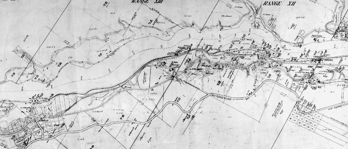
Locations for settlers were given by lot number and range number (often in Roman numerals ) I do not have an early map showing the lots in Hull Township. Some maps show Hope Bay split between lots 23A and 24A, others show it completely surrounded by lot 23A. The north-east side is mapped as shown in a 1960 map used by the NCC (disregard the dotted roads shown (a parkway planned but never built):
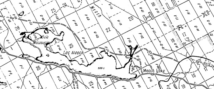
This area is completely in the Township of Hull, in the former municipality of West Hull, now Chelsea. It consists of the following lots in Range 13, just touching the lake-28A, 28B (east and west sides), 27B, 26B, 25B. In Range 12, lots 27A, 27B, 237C, 27D, 26A, 26B, 26C, 25. In Range 11, 26A, 25A, 245A, 23A, 22A, 22B, 21A, 21B, and in range 10, 22A. In all cases but the first, the lot lettering is A,B and C north to south.
The Gatineau Valley Historical Society has made a map with local tax payers in 1875, as follows:
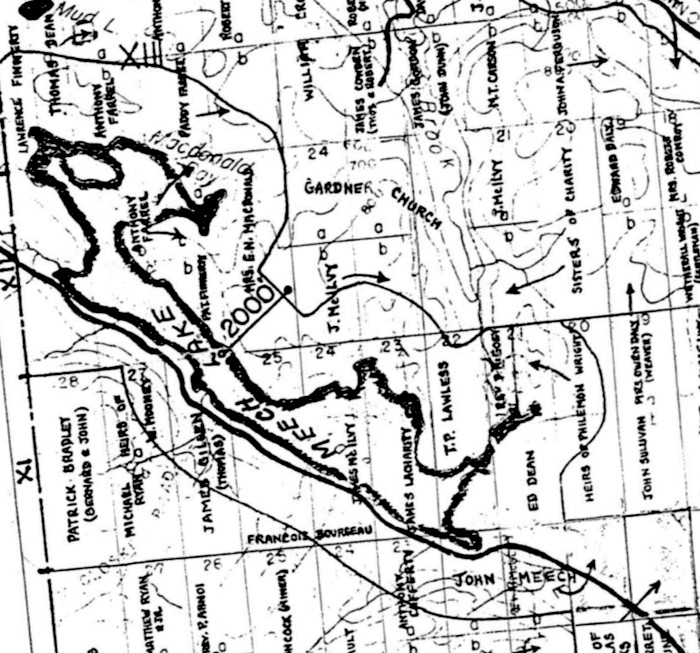
Some of the names should be spelled differently Mrs E H MacDonald is Mrs E H McDonnell, J McIlvy is J McKelvie, and T P Lawless is J P Lawless.
Here is a table of the Grantees (those receiving the Crown Grant), those on the 1875 map, and those on the 1941 FDC map.
| Range | Lot | size | Grantee | Grant date | 1875 taxpayer | 1941 owners |
|---|---|---|---|---|---|---|
| 13 | 28A | 100 | Lawrence Finnerty (W) | 11 avril 1872 | Lawrence Finnerty | H Davy |
| 13 | 28B | 100 | Patrick Finnerty(E) | 31 mars 1865 | Thomas Dean | |
| 13 | 27B | 100 | Elisée G Laverdure | 2 novembre 1878 | Anthony Farrell | |
| 13 | 26B | 100 | Patrick Farrell | 11 avril 1872 | Paddy Farrell | |
| 13 | 25B | 200 | Patrick Farrell | Paddy Farrell | ||
| 12 | 27A | 26 | Wm Brown & Anthony Farrell | 19 décembre 1864 | McGrath estate | |
| 12 | 27B | |||||
| 12 | 27C | |||||
| 12 | 27D | ? | ||||
| 12 | 26A | 33 | Charles Flynn, jr | 19 décembre 1864 | Anthony Farrell | Tilley estate |
| 12 | 26B | Patrick Finnerty | ||||
| 12 | 26C | Anthony Farrell | ||||
| 12 | 25 | 100 100 | (N) Patrick Farrell (S) Margt Farrell, veuve de feu Ed McDonald | 26 mai 1886 28 mars 1867 | Mrs E H MacDonald | Cross/John Hope |
| 12 | 24B | 100 | James Lacharité | 24 juillet 1862 | J. McIlvey | |
| 11 | 26A | ? | ||||
| 11 | 25A | François L Lacharité | 5 octobre 1853 | Francois Bourgeau | Hope | |
| 11 | 24A | François L Lacharité | 5 octobre 1853 | James McIlvey | Hope/Capuchins | |
| 11 | 23A | 54-1.2 | James Lacharite | 18 juin 1868 | James Lacharity | Hope/Gilhooley |
| 11 | 22A | Philemon Wright | 21 septembre 1827 | T. P. Lawless | ||
| 11 | 22B | Philemon Wright | 21 septembre 1827 | T. P. Lawless | Gilhooley/O'Brien | |
| 11 | 21A | Philemon Wright, sr | 16 Février 1832 | (West) Rev. P. McGoey | ||
| Philemon Wright, sr | 16 Février 1832 | (East) heirs of Philemon Wright | ||||
| 11 | 21B | Philemon Wright, sr | 16 Février 1832 | Ed Dean | ||
| 10 | 22A | Asa Meech, sr | 21 septembre 1827 | John Meech | O'Brien |
Range 13, just touching the lake-28A, 28B (east and west sides), 27B, 26B, 25B. In Range 12, lots 27A, 27B, 27C, 27D, 26A, 26B, 26C, 25. In Range 11, 26A, 25A, 24A, 23A, 22A, 22B, 21A, 21B, and in range 10, 22A.
The first settler was apparently Asa Meech, and Philemon Wright took title to the eastern parts of the area at about the same time. The Lacharité family obtained title in the 1850s, and the (related) Farrells in the 1860s. The Finnertys also obtained title in the 1860s. It is likely that the Lacharité and Farrell /McDonnell families arrived at about the same time, about 1844.
A 1931 map shows clearings, evidence of agricultural activity:
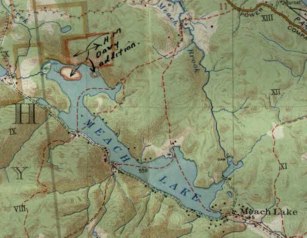
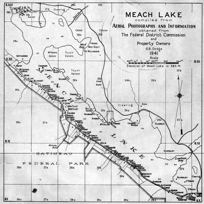
The 1941 map of Meech Lake shows landowners at that time.
2. Asa Meech
Rev. Asa Meech [1775-1849]2, Mary Dewitt, Maria Dewitt [-1822], Elizabeth Docksteader [1798-1853] (Lots 20, 21 and 22, Range 10)
There is a great deal written about the Meech family, and here is a short summary. Asa Meech [1775- 1849] was born in New England, was ordained and served as pastor in First Congregational Church3, Brockton, Mass. from 1800 to 1811, graduated from Brown University in Rhode Island in 1806, and served as pastor of the Congregational church in Canterbury, Conn, until 1821, although he visited Hull about 1815. He and the family at that time then emigrated to Canada about 1822 and they took up three 200-acres lots near Meech Lake, on range 10, lot 20 to son Asa Jr in 1827, lot 21 to Asa in 1824, and lot 22 to Asa in 1827. The Meech house is on lot 21, and lot 22 has some shoreline on Meech Lake.
Meech had three wives. He and the first, Mary DeWitt [1771-1809] had 6 children of whom 2 survived childhood, Asa Jr [1803-] and Mary [1805-]. After obtaining his land near Chelsea, Asa Meech Jr sold the land to his father and moved near Vanleek Hill, Ont. Mary married Rev. John McIntyre, Methodist minister at Chelsea in 1840, but McIntyre left that church over doctrinal issues in 1841.
After the death of his first wife, Meech married Maria DeWitt [1778-1822], Mary's sister, and they had 5 children, and emigrated to Canada. But Maria and children Timothy Dwight [1817-1822], Abigail [1819-1822], and Ezra [1821-1822] died on the bridge across Brewery Creek in Hull at what is now Tache Blvd in the spring floods of 1822. The other 2 children of the second marriage were Samuel Niles Meech [1811-1910], who went to Oxford Twp, Ont, and Thomas [1813-1849], of whom little is known.
Asa Meech then married Margaret Docksteader [1798-1853] in Nov 1822 in Argenteuil, and they had 2 sons and 6 daughters. Margaret Meech [1824-1904] married John Gordon of Aylmer, and their granddaughter was Ethel Penman Hope who summered on the lake, was an author, and wrote an early history of Meech Lake4. John Docksteader Meech [1825-1901]married Mary Elizabeth Church. John was active in the church as a Sunday School teacher, and farmed on the family lots until 1901. Two of John and Mary's children sons, Stephen and Silas, drowned in the lake in 1883. Cecilia Lucretia Meech [1827- 1915] married Rinaldo McConnell in 1847 and they lived in Mattawa. Harriet Newell Meech [1829-1893] married John Harrington and lived near Lac Mousseau for the 1851 census, and later on the Mountain Road. Maria Meech [1834-1882] married Richard Bolton and lived in Nebraska. Charles George Meech [1836-1881] married Ellen Moore, daughter of David Moore of Aylmer. Charles spent time as a lumberman and slipped on logs, was rescued, but died of exposure in 1881 on the Mattawa River. The author Marion Agnes Meech was a grand-daughter. Cynthia Meech [1839-1920] married Stephen Glazier and they lived in Portland, Oregon.
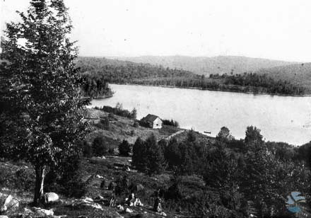
The noted historian, archivist, cross-country skier and sometime Meech Lake resident, Dr. Lucien Brault, in a short history in the newspaper Le Droit tells of transportation from Hull to and from Ste Cecile de Masham. In the 1840s the trail was not suitable for a wagon, and so people in the summer went by the three lakes. Canoes and flat-bottomed boats were used to carry people and loads. At the eastern end of Meech Lake one transferred from a carriage or wagon to Chelsea, and thence to Hull and Ottawa. The Meech house was used by travellers overnight, and up to a dozen could be accommodated in a den in the house.
The Meech Lake Road was apparently widened from a trail to a road to McCloskey Road, perhaps by 1850, by James Gillen [1800-1888] who with wife Ellen Gilligan had children Bridget (married, of age, to David Bradley in 1859) , Michael (1839-1905), Ellen (1841-), Thomas (1843-1909) and Mary (1843-) (married to Thaddeus Walsh). The road must have extended to Lac Mousseau by 1851 since Eardley surveyor Driscoll shows the road on his map (although the alternate route to the east end of Lac Mousseau shown is the trail that currently goes from Cross Loop to the Healey farm.)
3. Hope Bay
3.1 François Lacharite [1794-1874], Mary Moon and Miriam Mcneilly [1792-1859]
There is also a great deal written about the Lacharity family, so we merely provide a précis. François Lacharité5 [1794-1874] was born in Nicolet parish, Trois Rivieres, Quebec, the son of François Lacharité and Marie Louise Raiment. He enrolled in the British Army in 1812, aged 18, in the 100th Regiment of Foot. He was recruited by Ensign Pilkington, the commissaire of the regiment. This regiment, also known as Prince Regent's County of Dublin Regiment, was raised in Ireland, for the Napoleonic Wars, in 1804. It was sent to Nova Scotia in 1805, and was guarding Quebec in 1807. It saw service on the frontier during the war of 1812-15, first at Sackett's Harbour and the Sorrell River in 1813. The whole regiment took part in the capture of Fort Niagara in December 1813. From there, the men were engaged on raids to Buffalo and Black Rock in late December 1813. In July 1814, the regiment saw action at the Battle of Chippewa and then served at the Siege of Fort Erie. The regiment was renamed the 99th in 1816 and disbanded in 1818, and many soldiers were given land in Goulbourn Twp., Ontario, near Richmond, including Lacharité.

Thus, by 1822, war veteran François and first wife Mary Moon were in Goulbourn Twp near Richmond, on the eastern half of lot 24, range 6. They had one child, Jane Josephine Lacharity [1822-1896] who married Owen Daley [1811-?] in Aylmer in 1844. Owen and Jane had children Sarah [1849-], Mary [1851-1920] who married John O'Rourke [1861-1891], Catherine [1855-] who married Joseph Filiou , James [1857-1892] and Jane Josephine [1864-1893]. Since Aylmer is distant from Richmond, it is likely that Lacharity was in Quebec before the 1844 marriage of daughter Jane.
After the death of Mary Moon, François and second wife Miriam McNeely [1792-1859] were married in 1824 in Richmond, and there is a record of the baptism of daughter Susanna in 1836 in Richmond. Their children were Elizabeth [1825-1914] who married John Doucet [1831-1875], Johanna [1825-1922] who married Patrick Farrell [1828-1916] and the couple took over the farm on Meech Lake, and are described in more detail, James [1831-1892] who married Dudana Farrell, Augustine [1834-1907] who married Catherine Daley and they had at least 9 children and took over the family farm on the Gatineau River which later became part of the Larrimac Golf Course, and Susanna [1835-1898] who married Joseph McNeely [1832-1923] and they lived in Ashton, Ont.
The Lacharités then moved to Hull twp in Quebec. First they lived on a farm on the Gatineau River, lots 14 and 15, Range 12. This location was called Lacharity Landing, between Burnet and Kirks Ferry, and finally Larrimac. This land remained in the family until the flooding of the river and the formation of the golf course at Larrimac.
Subsequently Francois Lacharité moved to Meech Lake where he took title to lots 24 and 25 of range 11 in 1853. The Lacharités likely built the precursor to present-day Hope House. Francois was active in St Stephens Church in Old Chelsea. Lacharité was enumerated on lot 24 of Range 11 of the 1851 census, with neighbour and son-in-law Patrick Farrell on lot 27 of ranges 12 and 13. Lacharite and wife Miriam lived with the Patrick Farrell family until their deaths. After moving to Meech Lake, most of the neighbours were English-speaking, as was his wife, and the name Lacharité was anglicized to Lacharity or Lasharity, and all three spellings are common, as well as others. François became Francis. His tombstone reads 'Francis Lasharity'.
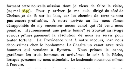
We know a great deal about this family because of Francois' contact with officialdom:-the Army, the land grant system, and with the Church. For example, we know exactly where he was on 24 May 1849. On that date Bishop Guigues of Ottawa set off to visit Ste Cecile de Masham, After taking a coach to Old Chelsea (St. Stephens was well established by that date) he had to find his way north, and he records that he prevailed on three men to transport him there, including Francois!
James Lacharity [1831-1892], Patrick Farrell [1828-1916] and Johanna Lacharity [1828-1922] took over the property of Francois Lacharity, but, it appears that Patrick Farrell never had legal possession of these lots. James augmented the territory with crown grants of lot 23A range 11, completing the shore of Hope Bay, and lot 24B of range 12. In 1898 the living descendants of long-deceased Francois Lacharity passed the following areas to James Farrell [1860-1933], the son of Patrick and Johanna, viz., lots 23A, 24A and 25A of range 11, and parts of lots 23B and 24B of range 12. Thomas Dean sold the south half, 100 acres of lot 25 range 12 to James Farrell in 1901. Patrick and Johanna gave the northern half of lot 25, range 12, to Miss Suzanna Farrell and Margaret Farrell, the wife of Michael Scott, in 1910, and they in turn sold the same property to Patrick Farrell in 1928 and Patrick in turn returned it to Margaret Farrell, wife of (deceased) Michael Scott in 1930. But in 1916 John Farrell sold his land to John Hope.
Patrick Farrell [1828-1916] and Johanna Lacharity [1828-1922] are seated, James [1860-1933] and wife Edith O'Meara [1869-1948] and children Joseph [1904-] and Mary [1905-] are shown, and to the left is William John (Jack) [1872-1936]. James and Edith had also children James [1907-], John [1908-] and Morris [1910-].
3.2 Paddy Farrell and Owen Daley's Night Out
Mrs Sheila Thomson's book describes this event from two person's recollections. The first is by Homer Cross [in the company of Richard Mulvihill and John Cafferty], page 95, the second is by John Cafferty [alone], page 151. The stories agree. Brothers-in-law Paddy Farrell, husband of Johanna Lacharity, and Owen Daley, husband of Jane Josephine Lacharity, , had been drinking and were in an ugly mood. When Owen returned home, Mrs Daley took the children and hid in the barn. Paddy continued home. Mrs Daley and children stayed in the barn while the house burned down. Apparently they did not leave the barn because she feared they were being pursued, by candle-light. In the morning Owen Daley was nowhere to be found. The story arose that he had lit the fire and gone to the United States; this was reinforced when his dog was found, shot. A neighbour stated that he saw Owen Daley in the United States, but was asked not to reveal his location. John Cafferty called the farm 'the Widow Daley's place'.
The two could have been drinking at Daley's, but if they were at a pub it was likely the closest, the Kirk Tavern in Kirk's Ferry. If Farrell left Daley, it means that Daley lived on the way to Farrell's home on Hope Bay. The location of Daley's farm is harder to pin down. Both accounts agree that it was on the road that is an extension of Cowden road that was first cleared by Owen Daley and runs to O'Rourke's Clearing and thence to Meech Lake near P9. Homer Cross recollected that the farm was in the first clearing, John 11 Cafferty that it was south of Baldwin's on the old weaver woman's road. From examining the census for 1871 and the West Hull tax records for 1875, it appears that Owen Daley left between 1871 and 1875. In the 1875 tax records that land owned by Mrs Owen Daley (weaver) includes O'Rourke's clearing, and that Mrs Daley passed the farm to her daughter, the wife of O'Rourke. There is still rhubarb growing there, and a basement is quite obvious. The trail that the two might have taken is roughly (but east of) that which currently goes from Larrimac Golf Course through a large culvert under Highway 5, and to Carbide Willson's Mill, and thence to trail 36 and west to Hope Bay. It is about 2 miles from Kirk's Ferry to O'Rourke's Clearing, and 1.5 miles from there to Hope Bay, as the crow flies.
3.3 The Hopes
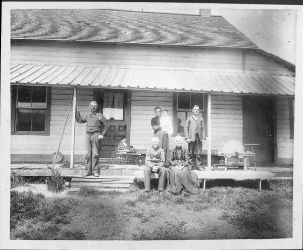
John Hope [1870-1956] and Ethel Margaret Helen Penman [1885-] lived in Ottawa; he was a merchant operating a bookstore. They had children Evelyn Ethel (1907-2005) wife of Hugh MacMillan, and Shirley May (1912-1968) who married Wilbur Austin Johnston [-1982] in 1960, and the Hope land and buildings were sold to the NCC in 1969.
Evelyn MacMillan letter to NCC
September 10 1978
10 Driveway
Dear Mr Latté
As you suggested I am writing you a history of what I can remember of the Meech Lake home my father purchased in 1916. From 1914-1916 he leased the property.
The original ownership is uncertain. Mr Lacharity lived here, and my father purchased from Farrell, but Mousseau also lived in it.
In 1922 the lean-to kitchen was raised in order for the basement to be properly ventilated. At this time the yellow brick fireplace, pantry, kitchen and small all-purpose room were added. The late John Kingston was the architect. The entire house was plastered by a Mr. Squirrell who also did the House of Commons. The present wall paper is a very recent defect.
In 1914 the house was log. The floors downstairs hardwood under 5 coats of paint. There was a trap door in the 2 smaller bedrooms upstairs and a wood stove in the underneath rooms with a pipe going up to heat upstairs. The trap door in the cupboard off the living room opened into the earth cellar and there we kept our milk and butter.
The present barn right was an ice house. The ice cut in the winter was stored there in sawdust, and so wekept meat and fish. The spring which still runs down from the hill was also used for perishables. This isabout all I can tell you; the photo will show the house as it was. Too bad the front porch with the canvastop interferes with the front view. The change is not so drastic, really. The stucco put in or about the same time 1922 makes quite a difference in the appearance.
I do hope the photo will help, and that I live to see the restoration!
Sincerely
Evelyn MacMillan.(According to her obituary, Evelyn MacMillan swam across Meech Lake in her 80s!)
3.4 Cadastral Lot 3029907
This little lot, 234 square meters, has a peculiar story. Originally part of John Hope's farm, it is now 10.55 metres wide and touches Meech Lake. When John Hope sold (Acte 2,210 Gatineau) a cottage lot to Henry Gill in 1935, he reserved access to the lake, a 'servitude', 25 feet wide, at the western end of the lot. Then, in 1953, Gill sold (Acte 35,520 Gatineau) part of his lot to John F Clifford, the ski entrepreneur. The servitude was maintained. Clifford in turn sold (Acte 64,504 Gatineau) his cottage lot to the NCC in 1964, but, for some reason, seems to have excluded the 'servitude' from the sale, although the language is murky. Thus, in 2019, John F Clifford, [although deceased] is noted in Chelsea Assessment records [Numéro matricule: 5144-97-6571-0-000-0000] as the owner of the lot, valued at $1100.
Capuchin Chapel. There are many articles about the chapel, built on land sold by James Farrell and John Hope.
3.5 Dominick Barrett [1819-1866] and Sophia Flynn [1816-1886].
They are listed in the 1861 census on lot 23, Range 11, the tract next to the Lacharity's. With them, they have children James [1845-], Mary [1847-1906], both born in Ireland and , Bridget[1853- ] born in Pointe- Gatineau . They came to Canada in 3 Dec 18466. Four Barrett brothers apparently came from Kilbride parish, Co. Mayo, Ireland, with one brother staying in Ottawa, two going to Cantley, and Dominick, the youngest. The 1861 census states that Dominick had 109 acres of land. However, the Crown grant was to James Lacharity for the northern half, 23A, of 54-1/2 acres in 1868, and the southern half to Thomas Watson, area not specified, in 1866. But when I measure these areas I come up with 70 acres for lot 23A and 19 acres for lot 23B on the south shore. Thus, it may be that the 109 acres is a misprint for 19. The witnesses for the burial in 1866 were James Gillen and Anthony Farrell. In 1871 Sophia is staying with newly married Felix McGrath and daughter Mary in lot 9, range 9, i.e. Chelsea Mills. James is recently married to Catherine Walsh. Bridget I cannot find.
The question is, did the Barretts settle on the south shore or north shore of the lake. The evidence seems to point to the south shore, since they were enumerated in 1861 next to James Gillen, who lived on the south shore, and they were not enumerated next to Francis Lacharity. The census shows 3 acres cleared, which could be on either side, I suppose, although the south side would be harder to farm.

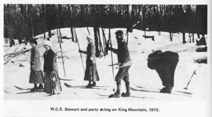
3.6 William Charles Evandale Stewart [1864-1946]
William Stewart, born in Quebec CIty, and an employee of the Post Office Department in Ottawa was one of the early cottagers on the north side of the lake, in lot 25a, Range 11. He assembled land from James Farrell in the early 1900s (Hull Actes 2210, 7096, 11664, 15371), and built the cottage in 1904. Stewart, a bachelor, was one of the earliest skiers in Ottawa, and the History of the Ottawa Ski Club points out that he borrowed a pair of skis from a Norwegian friend and had a copy made in 1897. He led people up King Mountain in 1907, accessing it first by climbing McCloskey Road. The same history has a photograph leading a group up King Mountain in 1912. He retired in 1920. At his death in 1946 he was cremated and his ashes scattered on Meech Lake, and his residence was Meech Lake.
King Mountain may mean Kingsmere Mountain, the name given to the plateau containing most ski trails. Lafleur mentions Stewart in his article
Stewart's cottage is shown on the 1941 map. in 1911 he is living in Ottawa with his mother Martha Wilson, sisters Harriett, Beatrice and Emma, and an aunt, Elizabeth Wilson. It is unclear from his will (Gatineau Acte 16517) whether the building on the south side of the lake was more than a garage; in any case the land and cottage on the north side was willed to the Salvation Army, and then sold to Ayton Keyes, and the land and cottage appear to remain in that family in 2019.
4. Macdonald Bay7
The early story of the region around MacDonald Bay is that of the McDonnell and Farrell families. Later the Davy family and Felix McGrath enter the story.
4.0 Charles Flynn Jr [1830-1918], Margaret Shea [1826-1865]
But first, we note that Charles Flynn Jr [1830-1918], son of Charles Flynn and Bridget Barrett, was granted by the Crown lot 26A range 12, 33 acres, and, according to the 1861 census, lived there with his first wife Margaret Shea [1826-1865] but apparently she died childless, whereupon he married Mary Gillespie [1848-1902] and moved up with the other Gillespies towards Lac Mousseau near Flynn Creek, where they farmed and logged, and raised a large family8. The original lot was with Anthony Farrell according to the 1875 map.
4.1 Farrels and Mcdonnells
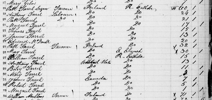
The 1951 Census has two Farrell families living on the north west corner of Meech Lake. The first family, that of widower Patt Farrell, Senior, has children, and Edward McDonnell, that will be discussed. The second Patrick Farrell family had three children born in the United States, and three in Old Chelsea, and documented in the St. Stephen's Church records. It turns out that this second Farrell family then emigrated to St Louis, Missouri; oddly enough family member William is replaced in the US Census by Francis. In the 1851 Census Patrick Farrell is located in lot 27 of range 12, and another the soon-tomove- to-Missouri Patrick Farrell is in lot 27, range 13.
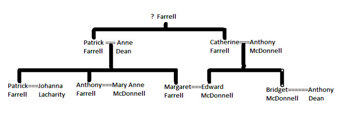
To understand the settlers in this northern area more, we have to understand the Farrell and McDonnell family tree.
Patrick Farrell [1794-1874] and Catherine Farrell were brother and sister, and from Co. Mayo, Ireland.
In the 1851 census on lot 27, range 12 we find Patrick Farrell [1794-1874] a widower of wife Anne Dean with Patrick [1828-1916], Anthony [1827-1893], Margaret [1835-1885, Thomas [1836-] and James [1836-], and Edward McDonnell [1831-]] . We have already met Patrick, the husband of Johanna LaCharity. Anthony Farrell [1827-1893], married his second cousin Mary Anne McDonnell [1826-] in Old Chelsea in 1854, the daughter of Patrick McDonnell and Mary McDonnell . See section 4.4.
In 1851 on lot 27, range 13, we find Patrick Farrell [1819-], wife Mary Montgomery [1821-], children William [1836-], Anthony[1838-], Betsy[1840-], Mary[1842-], James [1844-], Robert [1846] and Margaret Jane [1850]. Son William was born in Ireland, Anthony, Betsy and Mary in the USA, and James in Canada and Robert and Margaret Jane in Old Chelsea. This Patrick was, more or less, contemporary to the children of the settler on range 12, and, since his eldest son was William, he may have been the son of William Farrell, a brother of the elder Patrick. This Patrick Farrell is not the Patrick Farrell after whom Farrelton in Wakefield Township is named, since the Farrelton Farrell and his family also appear in the 1851 census. Subsequently Patrick Farrell and family moved to St Louis Missouri, and appear there in the 1860 Missouri Census as follows: Patrick 46, Mary 46, Francis 23 all born in Ireland, Anthony 19 b Ohio, James 15, Robert 12 and Margaret 9 born in Canada. In a subsequent 1880 Census for St Louis (1526 N 16th St) we have Francis 45 b Ireland, with wife Ellen, sons Robert and daughters Kate and Frances. Living as boarders we find Patrick 68 and Mary Morrison 65. Thus, the family stay in Canada was limited. The southern half of this lot, 27B, touching the lake, was granted to Elisée G Laverdure, a merchant, in 1878, although Anthony Farrell is the taxpayer in the 1875 map. The name of son WIlliam in the Quebec 1851 Census has become Francis in the Missouri 1860 census.
4.2 Edward Mcdonnell [1833-] and Margaret Farrell [1835-1885].
Catharine Farrell, sister of the elder Patrick, married Anthony McDonnell in Ireland and, and they had children including Edward McDonnell [1833-bef. 1871] and Bridget McDonnell [1835-]. Edward McDonnell [1833-bef. 1871] married his cousin Margaret Farrell [1835-1885] in Old Chelsea and they had children Mary [1855-], Anthony [1857-] , Catherine [1859-], Patrick [1861-], Edward [1862-]and Ann [1865-]. Edward's sister Bridget married Anthony Dean [1828-], one of the Dean brothers that settled along Pine Road. And one of the Dean children, Bridget, married the ancestor of the Healeys of Healey's cabin. Since they owned land on the bay, it seems clear that MacDonal;d Bayshould be named after the McDonnell family.
On the 1875 map we have three Farrell siblings
- Margaret Farrell wife of Edward McDonnell is the Mrs E H MacDonald on Lot 25, Range 12
- brother Anthony Farrell husband of Mary Anne McDonnell is the owner of lot 27B, range 13. 26C and 26A of Range 11, and 278B of range 11, and, presumably, Davy Island
- brother Patrick Farrell husband of Johanna Lacharity owning lots 26B and 25B of range 13 of the 1875 map.
I surmise that Anthony and Margaret both lived on their properties, whereas Patrick lived at Hope House.
4.3 Anthony Farrell [1827-1893] and Mary Anne Mcdonnell 1826-].
The family is in the Census over the period, apparently living on Davy Island, since the 1871 census gives their address as lot 27, range 12. The children are John [1855-] , Patrick [1856-1918], Mary [1858-1933], Anne [1860-1933], Bridget [1862-1929], and Edward [1865-], who probably died young. Anthony was Road Inspector for the Township of Hull and his area was basically the Meech Lake Road along the lake.
4.4 Felix Mcgrath [1841-1911] and Mary Barrett [1847-1906]
Felix and family are in the 1861 census in Chelsea, presumably at the Gilmour mill. We know (Acte 18228 Hull) that Miss Mary Farrell and Henry Bertschinger sold land to Felix McGrath on 25 Sept 1895, consisting of the lot 27B in range 13, 100 acres, and all the parts of lots 27A, 27B and 27C of range 12, except for the land sold to Felix McGrath by Anthony Farrell in 1892. In 1905 McGrath sold the south east part of lot 27A in range 12, 1 acre, and all the buildings on it, to Miss Clara Beatrice Davy of Oil City Pennsylvania, spinster, represented by her mother Annie Winiberg the wife of Richard Adams Davy, Civil Engineer, of Ottawa.
Felix McGrath [1841-1911] was born in Douglastown, Gaspe, Quebec. He and brothers William and Charles worked in the Gilmour Mill in Chelsea. He married Mary Barrett [1847-1906] in 1870 and they had children George [1870-], Domininck James [1875-] moved to Hamilton, Catherine Sophia [1877-], avid [1879-], James Henry [1881-1931], Sophia [1883-], Mary Maud [1885-] who married Thomas Green in Hamilton, and William Thomas [1873-1944].
Son William Thomas married Catherine Jane Dunlop [1877-1970] in 1903 and they had 6 children, and lived in Old Chelsea.
4.5 Paddy Farrell's Cash Cache
The Ottawa Citizen of 2 Aug 1900 tells of a Patrick Farrell who, he said, buried $50,000 earned as an employee of the Hawkesbury Lumber Company {the Hamilton successor] on a plot of land then owned by his father, and then left for one of the United States. Meanwhile his father sold the land to Felix McGrath. Farrell returned to Ottawa, but forgot the location of the cache. But, in a dream, he imagined where the cash was stored. He contacted Constable Proulx of Hull, who told Farrell to obtain a permit from McGrath before digging for the cash. We know not the outcome.
The Hawkesbury Lumber Company (a successor to the Hamiltons) has archived 6 metres of material in the Ontario Archives, so I suppose that there may a record of Patrick Farrell on the payroll.
Thus, Patrick [1856-] was the son of Anthony Farrell and Mary Anne McDonnell.
Yet another Patrick was the bachelor son of Patrick Farrell and Johanna Lacharity. He lived on lot 25, range 12, in a cabin. His will in 1932(acte Gatineau 3915) splits his estate between his sister Margaret and brother William John. He is mentioned in Francois Lafleur's article.
4.6 The Finnerty Family
There are three members of the Finnerty family from Co. Sligo of particular interest. L lot 28, range 13, which goes from trail 50 to Meech Lake, was occupied by Joseph Harrington9, 200 acres, in 1851.

But in the Crown grants, the lot was split in two, with the more westerly granted to Lawrence Finnerty, and the eastern half to Patrick Finnerty. In 1875 the easterly half was occupied by Edward Dean, after Patrick sold it to him in 1867.
Patrick Finnerty (1815-1883) and Winnifred Cooligan (1816-1900) apparently had one child Catherine aged 7 born in Upper Canada, in the Census of 1861. Lawrence Finnerty (1831-1886) , son of Thomas Finnerty and Bridget Dowd of Co Sligo, married Anne Daley (1836-1908) in 1858 and they had 10 children baptized at St Stephens in Old Chelsea, Bridget, John, Mary Ann, Patrick [1865- ], Catherine, Elizabeth, Lawrence, Sarah, Michael Thomas and Richard Edward. I suppose that Lawrence and Patrick might have been brothers. They were both in the 1881 census of West Hull. The family with widow Anne is in the 1891 census. In 1901 Anne is living with her daughter Mary Powers in Ottawa, but I cannot locate the rest of the family except Richard boarding with another family. By 1875 Patrick had located in lot 26B (S 1/2), range 12.
Of particular interest is the property at lot 26b and 26c of the 11th range. This was sold by Patrick, the son of Lawrence Finnerty, to W J Tilley in 1885., and reinforced in 1886 since at the time of the initial sale, Patrick was a minor.
According to John Cafferty in Mrs Thomson's 'Recollections', the Finnerty property on lot 28 was later occupied by Mr Burke, and then fur farming was started on the Finnerty property by Mr Clark. In 1935 Col Edwards asked Harvey and Jean Doraty from Saskatchewan to take over the fur farm, and he and his family lived here till 1953, shortly after Edwards and Herridge sold the land for inclusion in Gatineau Park, when the Doratys retired to Stittsville10. Mrs Carol Martin of Farm Point, a prominent local historian very involved with the Gatineau Valley Historical Society, was related to Mrs Doraty, and has written extensively about the Avion Fur Farm11. The concrete foundations of at least two of the farm buildings remain, as well as the well of the farm house, near trail 50. A frame building for farm workers was dismantled, taken to Stittsville, and used as the Doraty home there.
We note that Dr Donald Hogarth noted12 a mine and an access road, as shown. This may explain the culvert holding the water leaving lac Trudel.

4.7 William James Tilley [-1908] and Mary Ann Bell [-1926]
William James Tilley was a civil servant in Ottawa who was a very early vacationer on the Lake. The cottage was on the south side of the lake just west of the McCloskey Road, (and P12), shown in the 1941 map. But Tilley also purchased land on the north side. He purchased lot 26B in range 13 from Patrick Farrell (husband of Johanna Lacharity) in 1885, including a house, which land Farrell had obtained by Crown Grant in 1872. He purchased the land on the south shore, in lot 26B, range 11, from Thomas Gillen in 1888, and it is still apparently in private hands. He purchased lots 26B and 26C of range 12 from Patrick Finnerty the son of Lawrence Finnerty, likely in 1904. After W J Tilley's death in 1908, Tilley's widow sold the lot 26B in range 13 to Harold Mortimer Davy in1919, and she herself died in 1926. The land remaining in the estate, lots 26B and 26C in range 12 was sold to the FDC in 1954.
William James Tilley was so fond of Meech Lake that he was initially buried there, but his grand-children had his body disintered and reburied to Beechwood cemetery in Ottawa.
4.8 Davy Family13
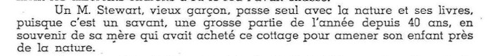
Robert Adams Davy [1852-1937] was a surveyor and engineer living from time to time in Ottawa, and had dealings with the Railways and Canals Dept in Ottawa, where W J Tilley worked. He and his wife Annie [1853-1934] had children Annie, Clara, RIchard, Harold, Walter, May, Kathleen and Constance. The children began purchasing lots at the north end of Meech Lake, starting with Clara Beatrice Davy [1873-] in 1906, of a 1-acre lot, she then of Oil City, Pennsylvania, from Felix McGrath, apparently a cottage lot on Davy Island. Her brother Harold Mortimer Davy [1877-] accumulated land between 1914 and 1918, and ultimately sold it to the FDC in 1952, including lot 27A of Range 12, and lots 26B and 27B or Range 13, and the islands in lot 29 range 12, 28A and 28B in Range13. Lot 26B of Range 13 had been obtained from Tilley in 1918, and lots 27B of range 13 and 27A of Range 12 were purchased from Lovina St Denis, the widow of Ovila Chenier , in 1914. H M Davy was married twice, to Lillian Sansfaçon [-1938], and to Marjorie Gammon.
We have a Davy anecdote in Francois Lafleur's Notes Historique of 1945, which may date from about 1925:
It is presumably Harold Mortimer Davy's wife Lillian that Lafleur mentions.
Some maps show this as Davey or Davies Island. Oh dear.
4.9 Ginseng
Wild ginseng was once harvested near Meech Lake. The plant is rare and endangered in Canada, and harvesters face a heavy fine, apparently as much as $250,000. Stands of fewer thast 150 plants eventually perish.
The story is told by Stan Cross14, that a squatter named Proulx on lot 28, range 12, had found a growth of ginseng nearby, and showed up in the spring of 1927 or 1928. Later the Proulx sons Paul, Levi, Alex and Joseph showed up. Joseph was an excellent trapper for muskrats on Lot 26, range 12, former McGrath land. Cross recounted that the family of Joseph later lived at 13 Scott St in Hull, and that they perished in a fire there15. The Proulx's did not divulge the location of the ginseng.
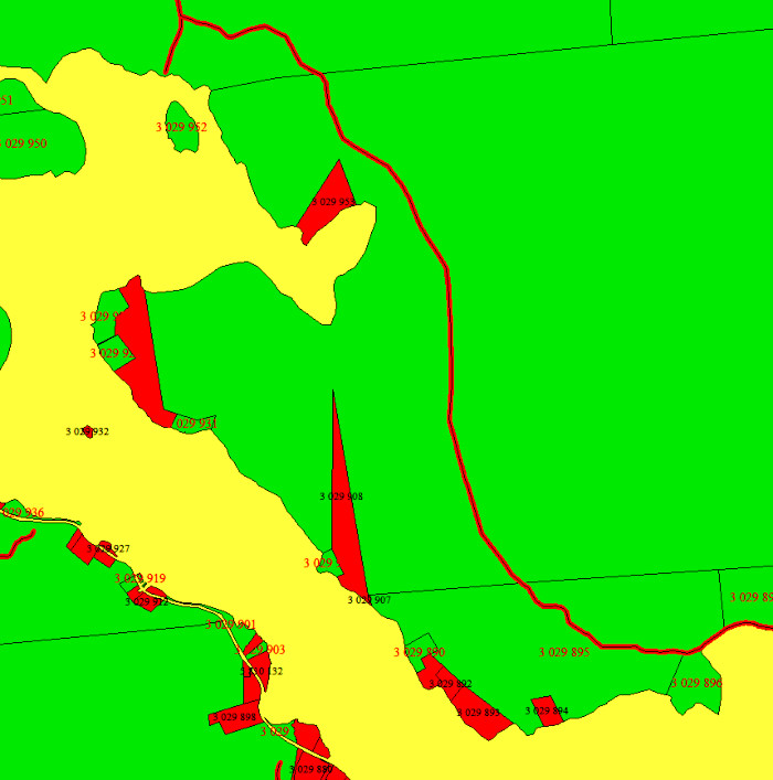
5. Current Land Owners
The current private property is shown on the next map in red, NCC land in green.
6. Thomas Leonard Willson
Thomas Lionel Willson assembled a large area in the early 1900s for his mill on Meech Creek. This, and the ruins of the effort, are well documented.
7. Cross and Mckelvie Family
Wyman Cross, farmer, William H Cross, farmer, Leslie B Cross, farmer, Milton D Cross, lumberman, and Stanley R Cross sold a large tract to the FDC in 1953, consisting of lots 19A in range 11, 18A, 19A, 22, 23A, 24A and N 1/2 25, parts of 23B and 24B not owned by the Hopes in range 12, 21B, S 1/2 24, 25B, 26A of range 13, s 1/2 of N 1/2 of 27, parts of 25B, less the servitude for the Bell line granted in 1948, and not including certain mineral rights. Here is a map prepared by the FDC showing the Cross (and other lands) between Meech Lake and Meech creek and beyond.
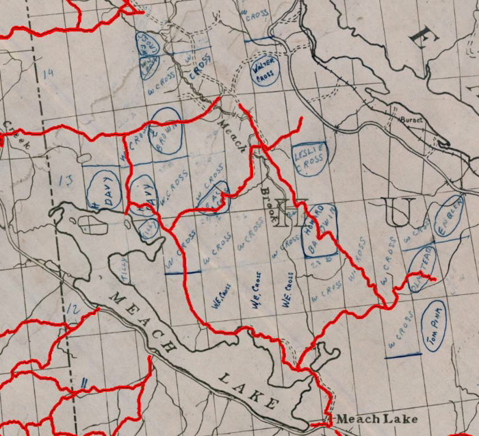
The name J McIlvy on the 1875 maps refers to James McKelvie, who lived south of Cowden Road, on the trail built by Owen Daley to go to P9 and Old Chelsea bypassing the main highway with its toll gates. McKelvie's daughter, Mary Anne, married William Cross, and it is their grandchildren that appear in the list of Crosses above.
| Range | Lot | Grant | 1875 | History after 1900 (incomplete) |
|---|---|---|---|---|
| 11 | 19A | Richard Dailey, sr | Mrs Owen Daly (Jane Lacharity) | Owen Daly Jane Lacharity Mary Anne Daly Freeman Cross Wyman Cross (1940) |
| 12 | 18A | Wm Hamilton | Mrs Robert Conroy | W J Conroy Wm Cross Freeman Cross Wyman Cross (1940) |
| 19A | Edward Dailey | Edward Daly | Edward Daly James Hammond Freeman Cross Wyman Cross (1940) | |
| 22 | Thomas Watson | Gardner Church | William Cross Freeman Cross Wyman Cross (1940) | |
| 23A | George Edmonds | Gardner Church | William Cross Freeman Cross Wyman Cross (1940) | |
| 23B | James LaCharité | J McIlvie | William Cross Freeman Cross Wyman Cross (1940) | |
| 24A | Thomas Watson G | ardner Church | Wyman Cross (1040) Stanley Cross (1948) | |
| 24B (excluding Hope Property) | James Lacharité | J McIlvie | James McKelvie William Cross Freeman Cross Wyman Cross (1940) | |
| N-1/2 25 | Margt Farrell, veuve de feu Ed McDonell | Mrs E H McDonnell | Thomas Dean James Farrell Margaret & Suzanna Farrell Patrick Farrell Mrs Michael Scott Wyman Cross | |
| 13 | 21B | John Carson | M T Carson | Hugh Carson Mrs Elizabeth Bates Carson William Cross George and Wyman Cross Leslie Cross |
| S-1/2 24 | William Cross | William Cross | William Cross Wyman Cross William H Cross Adam Newton Brown Comm. Urbaine Out. | |
| 25B | Patrick Farrell | Paddy Farrell | Desire Treau de Coeli William Cross Wyman Cross Milton Cross | |
| 26A | Anthony Dean | Anthony Dean | Anthony Dean John Alexander Gordon Mary Ann Dean (his wife) Richard Henry Gordon Wyman Cross Stanley Cross | |
| 14 | 25B | Les rep lég William Ash | Wm Ash | William Henry Ash et al Wyman Cross William H Cross Harvey Cross Donald Richard Whyte & William Parks Soc. Am. Outaouais |
| S-1/2 of N-1/2 of 27 | Canada Iron Company | Sisters of Charity | John Hendrick Michael D Hendrick Freeman Cross Henry Baldwin Jason Baldwin Allen Lawrence Hendrick Wyman Cross |
8. Ski Routes
This area lacks roads. A 1925 map shows ski routes that cross the area, as shown.
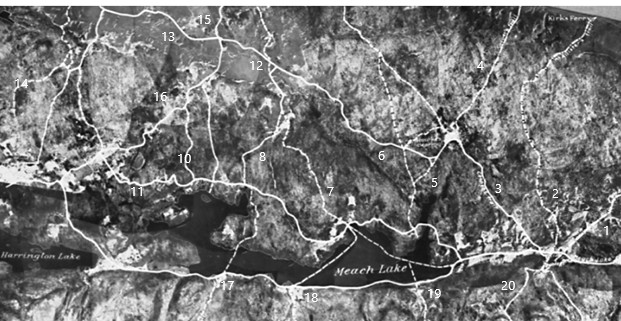
1925 map 'Mosaic of Ottawa and Meach Lake District showing Travelled Routes'.Original in Moorside, Kingsmere, and GVHS Image CD-019/02147 (part). Partial list: 1. Tenaga trail. 2. McAllister trail to Kirk's Ferry. 3. road to O'Rourke Clearing. 4. Cooper trail to Kirk's Ferry 5 Giants trail Mill to O'Rourke's clearing. 6. Daley extension of Cowden Road to avoid highway 7. Hope trail. 8. Lake trail.9. missing 10 MacDonnald Bay trail. 11 Trail to Fox Farm. 12 Cowden Rd. 13 Cross Loop . 14. Trail to Healey farm. 15 Pine Road 16. Fox Farm Rd. 17 Blanchet trail (P13) 18 McCloskey Rd (P12) 19. Alexander trail 20. Keogan Rd.
Acknowledgements
Mrs Sheila Thomson for her book, and discussions.
Ms Karen Tam of the NCC Information Centre Aug 2019 for photographs and information on Hope House.
Wallace Schaber and Gershon Rother for encouragement.
Mary Brown for Lacharity information.
Michel Mercier of the NCC for the NCC Lot map.
Michel Lemaire for Meech Lake maps.
Footnotes
- A talk on this subject was given to the Friends of Gatineau Park in Nov 2019, Gershon Rother organizer. There are a variety of spellings for various family names. We use Meech, Lacharity, Farrell, MacDonald Bay (which is mis-named), McKelvey and Tilley.
- Marion Agnes Meech, 'Asa Meech', Up the Gatineau!, vol 7, pp 14-18.
- The Congregational Church in Canada was one of the founding churches of the United Church of Canada in 1925.
- Ethel Penman Hope, 'Early Settlement of Meech Lake', Up the Gatineau:, Vol 10, 1984, pp 22-26.
- His birthdate is obscure. The British Army records indicate 1794, the Census indicates 1791. If the first, he baptized 7 Sept 1795 the son of Francois Lacharite and Marie Louise Raiment, otherwise he was baptized 20 August 1792 the son of Joseph Lacharite and Marie Dupuis. Both in Nicolet parish.
- One Ancestry immigration record indicates 3 in the party, another 4. Mary's birth date is not precise; I guessed from census data.
- This should be called McDonnell Bay, as we explain
- Large enough for a grant of a free farm in Pontiac Co.
- John Cafferty told Mrs Sheila Thomson that the Harringtons (Hetherington) had 4 connections with Lac Mousseau, and, given the 1851 Census reference, Joseph Harrington may very well have been the first settler in the area. The Hetheringtons later settled on the Mountain Road, and that property is partly in the park which property is still (2018) private. Michael Reford published a paper on the Mountain Road property: Michael Reford, 'The Hetherington Farm', Up The Gatineau!, Vol 19, pp 31-35.
- Son John Doraty led a hike to the Farm about 2012 and recounted that the NCC built trail 50 to Pine Road in Cascades shortly after their departure, and this road sliced through their back yard.
- Carol Martin, 'Avion Fur Farm', Up the Gatineau!, vol 29, pp 17-21. Also Carol Martin, 'The Old Fox Farm in Gatineau Park', The Gatineau Park Chronicle, Fall 2007, NCC. Also several photographs on the GVHS website.
- D. D. Hogarth, Geology Of The Gatineau Park (South Part) And Surrounding Area, gscprmap_7- 1970_e_1970_mn01.pdf
- The Davy's came from the same area in Cornwall as the renowned English chemist Sir Humphrey Davy, but I know of no connection.
- Stan Cross 'The Trapper,' Up the Gatineau!, vol. 18, pp 31-34, 1992.
- Ottawa Journal, 14 Sept 1962, '6 of Hull Family Burned to Death in Flash Fire'.