Gatineau River: Then and Now
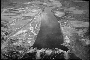
Lower Gatineau River from the air in 1926 and 1997
Set 6 - The Gatineau River Yacht Club island (Click on images for additional details)
The THEN photo shows the terrain that is now the island where the Gatineau River Yacht Club is located. The rock pile at the west end of the Eaton Chute marks one boundary of the new island. Before the water level was raised, the riverbanks ran almost parallel, for about a mile from the Eaton Chute to the northern limits of Kirk's Ferry.
NOW, the shorelines are no longer straight, and a hill has become an island. (The Gatineau River Yacht Club purchased the island in the 1960s.) Much farmland on both sides of the river was flooded. For more details, see Allan Richens' article "The Early Years of the Gatineau River Yacht Club" in Up the Gatineau!


